
A recent workshop held at the Pawsey Supercomputing Centre in Perth for academics and industry experts revealed an amazing new resource for simplifying the process of biodiversity-climate change modelling. The Biodiversity and Climate Change Virtual Laboratory (BCCVL) is operated by Griffiths University and utilises supercomputers to model the potential changes in species distribution in response to climate change scenarios.
The BCCVL can access world-wide datasets and incorporates hundreds of species, models and climate variables. For those of us interested in Western Australian species, the BCCVL allows users to import species data directly from the Atlas of Living Australia (or your own dataset) and apply the latest CSIRO developed climate change projections for Australia.
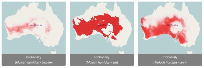
Species distribution modelling has been difficult in the past due to a lack of standardised data and methods and computational limitations. The BCCVL gives quick and easy access to the available models, species data and does the computation ‘in the cloud’ using supercomputers such as Magnus – the largest supercomputer in the southern hemisphere that is hosted at the Pawsey Supercomputing Centre. You will need a decent internet connection and will get the results in just a few minutes.
The BCCVL tool has many applications in the development of management strategies for our Wheatbelt region’s biodiversity and biosecurity!
The workshop also highlighted what a key resource the Atlas of Living Australia is and the importance of contributing data. If you’re sitting on some species distribution data, whether it is native or feral species, drop the ALA a line and get your data out there – it’s the building block for everything we can learn about how our biodiversity may fare in the face of climate change.